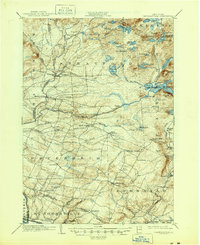
1945 Map of Lassellsville
USGS Topo · Published 1964About this map
Irish Settlement and several small mill communities characterize the southern slopes of the Adirondack foothills at the turn of the century. The landscape is defined by the complex water systems of Middle Sprite and Canada Lake, where early industrial activity is evident at Glasgow Mills and Newkirk Mills. The map documents a network of rural hamlets and family-named intersections like Phipps Cors. and Dempster Corners, illustrating the dispersed settlement pattern of Fulton Co before modern road consolidation.
Find a feature on this map
97 named features on this map. Tap any name to fly to it.
Don’t see what you’re looking for? This feature index may not catch every label — zoom into the map to look around manually.
Map Details
Editions of this 1945 Lassellsville Map
This is the sole edition of this map. No revisions or reprints were ever made.
Other maps of this area

1896 · Fonda
USGS Topo · 1:62,500

1898 · Fonda
USGS Topo · 1:62,500

1898 · Canajoharie
USGS Topo · 1:62,500

1900 · Little Falls
USGS Topo · 1:62,500

1900 · Canajoharie
USGS Topo · 1:62,500

1900 · Wilmurt
USGS Topo · 1:62,500

1901 · Lassellsville
USGS Topo · 1:62,500

1902 · Canajoharie
USGS Topo · 1:62,500

1902 · Fonda
USGS Topo · 1:62,500

1902 · Wilmurt
USGS Topo · 1:62,500