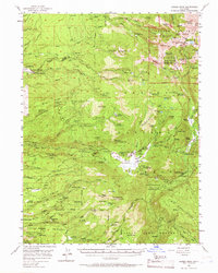
1956 Map of Lassen Peak
USGS Topo · Published 1966About this map
Lassen Peak dominates this volcanic landscape along the Shasta and Tehama County line, marking a region of rugged geothermal activity and early mountain industry. Lower elevations reveal a history of logging and ranching at Forward Mill and the Glines Ranch, while the Rockland School and nearby Cemetery at Lyonsville anchor small mid-century communities. The transition from industrial timber land to protected wilderness is evident as one moves toward Lassen Volcanic National Park, where features like Lake Helen and Emerald Lake sit at the base of Brokeoff Mountain. The map details early recreational and administrative infrastructure, including the Park Headquarters, the Ranger Station at Mineral Summit, and numerous legacy campsites like Shelton Camp and Dotys Camp.
Find a feature on this map
117 named features on this map. Tap any name to fly to it.
Don’t see what you’re looking for? This feature index may not catch every label — zoom into the map to look around manually.
Map Details
Editions of this 1956 Lassen Peak Map
3 editions found

Other maps of this area

1886 · Lassen Peak
USGS Topo · 1:250,000

1892 · Lassen Peak
USGS Topo · 1:250,000

1894 · Lassen Peak
USGS Topo · 1:250,000

1935 · Burney
USGS Topo · 1:96,000

1935 · Paynes Creek
USGS Topo · 1:96,000

1939 · Burney
USGS Topo · 1:125,000

1939 · Halls Flat
USGS Topo · 1:125,000

1941 · Mineral
USGS Topo · 1:125,000
1953 · Panther Spring
USGS Topo · 1:62,500

1955 · Westwood
USGS Topo · 1:250,000