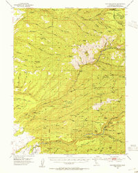
1953 Map of Panther Spring
USGS Topo · Published 1955About this map
Lassen National Forest terrain dominates this 1950s survey of eastern Tehama County, where the landscape is defined by the deep incisions of Deer Creek and Antelope Creek. A notable historical site is the Yahi Indian Camp (Ishi Caves) located along the canyon walls of Deer Creek, a place of significant cultural weight. The map captures a transition from high ridges like Dewitt Peak and Round Mountain down to the broken volcanic flats of Digger Pine Flat.
Find a feature on this map
117 named features on this map. Tap any name to fly to it.
Don’t see what you’re looking for? This feature index may not catch every label — zoom into the map to look around manually.
Map Details
Editions of this 1953 Panther Spring Map
4 editions found
Other maps of this area

1886 · Lassen Peak
USGS Topo · 1:250,000

1890 · Red Bluff
USGS Topo · 1:250,000

1891 · Chico
USGS Topo · 1:125,000

1892 · Lassen Peak
USGS Topo · 1:250,000

1893 · Chico
USGS Topo · 1:125,000

1894 · Lassen Peak
USGS Topo · 1:250,000

1894 · Red Bluff
USGS Topo · 1:250,000

1895 · Chico
USGS Topo · 1:125,000

1904 · Vina
USGS Topo · 1:62,500

1905 · Tehama
USGS Topo · 1:62,500