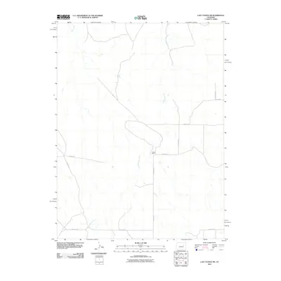
2010 Map of Last Chance SW
USGS Topo · Published 2010About this map
Middlemist Creek meanders through this portion of the eastern plains, defining a landscape of wide drainages and sparse ranching infrastructure. Near the center of the quadrangle, Brooks Ranch stands as a primary landmark, situated at the junction of County Rd-4C and County Rd-21. This 2010 survey reflects a period when the traditional agricultural layout remained intact, dominated by a grid of local corridors like Wardel Rd and Runway Rd. To the northwest, Beaver Creek carves through the terrain, illustrating the hydrologic patterns of the High Plains. The map's grid-based road system, including County Rd-1 and County Rd-3Z, suggests a region organized around large-scale landholdings and rural transit routes.
Find a feature on this map
13 named features on this map. Tap any name to fly to it.
Don’t see what you’re looking for? This feature index may not catch every label — zoom into the map to look around manually.
Map Details
Editions of this 2010 Last Chance SW Map
This is the sole edition of this map. No revisions or reprints were ever made.
Other maps of this area

1891 · Limon
USGS Topo · 1:125,000

1892 · Limon
USGS Topo · 1:125,000

1954 · Limon
USGS Topo · 1:250,000

1957 · Limon
USGS Topo · 1:250,000

1958 · Limon
USGS Topo · 1:250,000
1970 · Barking Dog Spring
USGS Topo · 1:24,000

1970 · T Draw
USGS Topo · 1:24,000

1973 · Last Chance SW
USGS Topo · 1:24,000
1973 · Cottonwood Valley South
USGS Topo · 1:24,000

1973 · Last Chance NW
USGS Topo · 1:24,000