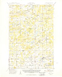
1950 Map of Lastrup
USGS Topo · Published 1950About this map
Lastrup and Harding serve as focal points for this mid-century portrait of central Minnesota, where the landscape is defined by a dense network of rural school districts and parish life. The map illustrates a highly localized social structure, with nearly two dozen educational sites such as District No 36 School and District No 123 School scattered throughout the townships of Pulaski and Belle Prairie. Religious centers like the Holy Mother of Rosary Church and Holy Cross Church anchored these agricultural communities.
Find a feature on this map
68 named features on this map. Tap any name to fly to it.
Don’t see what you’re looking for? This feature index may not catch every label — zoom into the map to look around manually.
Map Details
Editions of this 1950 Lastrup Map
2 editions found

Other maps of this area

1912 · Deerwood
USGS Topo · 1:62,500

1914 · Deerwood
USGS Topo · 1:62,500

1915 · Brainerd
USGS Topo · 1:62,500

1916 · Pillager
USGS Topo · 1:62,500

1918 · Brainerd
USGS Topo · 1:62,500

1919 · Pillager
USGS Topo · 1:62,500

1948 · Belle Prairie
USGS Topo · 1:62,500

1948 · Pierz
USGS Topo · 1:62,500

1948 · Lastrup
USGS Topo · 1:62,500

1948 · Little Falls
USGS Topo · 1:62,500