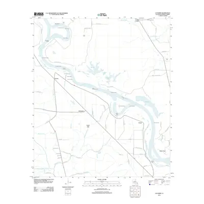
2012 Map of Latanier
USGS Topo · Published 2012About this map
The Red River defines the landscape of this Rapides Parish region, its winding course lined with numerous riverfront landings that speak to the area’s historic connection to waterborne commerce. Settlements such as Latanier, Whittington, and Poland anchor the agricultural interior, where a network of canals and bayous, including the Compton Lake Canal and Bayou Latanier, manage the low-lying drainage of the basin. The map reveals a high concentration of specific river access points, from Miller Bluff in the north to Jones Quarters Landing and Beaver Dam Landing further downstream. For genealogists and local historians, the placement of Peart Cem, Wise Cem, and Mount Pleasant Cem offers critical coordinates for family research. The interior is characterized by significant water bodies like Big Lake, Lockhart Lake, and Tiger Lake, illustrating the complex hydrology of the floodplains before the land transitions to more structured residential developments.
Find a feature on this map
84 named features on this map. Tap any name to fly to it.
Don’t see what you’re looking for? This feature index may not catch every label — zoom into the map to look around manually.
Map Details
Editions of this 2012 Latanier Map
This is the sole edition of this map. No revisions or reprints were ever made.
Other maps of this area

1935 · Lecompte
USGS Topo · 1:62,500

1940 · Marksville
USGS Topo · 1:62,500

1941 · Alexandria
USGS Topo · 1:62,500

1941 · Buckeye
USGS Topo · 1:62,500

1953 · Alexandria
USGS Topo · 1:250,000

1955 · Alexandria
USGS Topo · 1:250,000

1957 · Alexandria
USGS Topo · 1:62,500
1957 · Alexandria
USGS Topo · 1:24,000

1957 · Lecompte
USGS Topo · 1:62,500

1959 · Buckeye
USGS Topo · 1:62,500