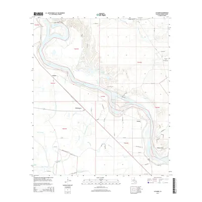
2015 Map of Latanier
USGS Topo · Published 2015About this map
The Red River meanders through Rapides Parish, shaping the alluvial landscape of central Louisiana. This survey highlights the intricate network of oxbow lakes and bayous that define the region, including Elbow Lake, Big Lake, and Tarkill Lake. Small rural communities are concentrated along the fertile riverbanks and local thoroughfares, with Latanier and Whittington serving as central points for the surrounding agricultural lands. The presence of several family and community burial grounds, such as Mount Pleasant Cem and Wise Cem, points to a long-established history of settlement in the river valley. The landscape is also marked by significant water management features like the Compton Lake Canal, which alongside Indian Bayou and Lick Bayou, illustrates how the local topography has been adapted for drainage and transport within the floodplain near Poland.
Find a feature on this map
66 named features on this map. Tap any name to fly to it.
Don’t see what you’re looking for? This feature index may not catch every label — zoom into the map to look around manually.
Map Details
Editions of this 2015 Latanier Map
This is the sole edition of this map. No revisions or reprints were ever made.
Other maps of this area

1935 · Lecompte
USGS Topo · 1:62,500

1940 · Marksville
USGS Topo · 1:62,500

1941 · Alexandria
USGS Topo · 1:62,500

1941 · Buckeye
USGS Topo · 1:62,500

1953 · Alexandria
USGS Topo · 1:250,000

1955 · Alexandria
USGS Topo · 1:250,000

1957 · Alexandria
USGS Topo · 1:62,500
1957 · Alexandria
USGS Topo · 1:24,000

1957 · Lecompte
USGS Topo · 1:62,500

1959 · Buckeye
USGS Topo · 1:62,500