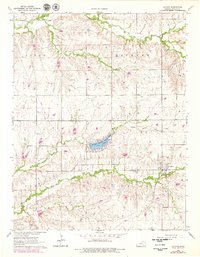
1964 Map of Latham
USGS Topo · Published 1979About this map
The town of Latham sits at the intersection of a sprawling creek network and the St Louis-San Francisco railroad in this mid-1960s Kansas landscape. Much of the surrounding terrain is defined by the deep incisions of Hickory Creek and Plum Creek to the north, while the southern half is dominated by the branches of Rock Creek. A notable man-made feature is Lake Clumer, located within Butler County State Park, which serves as a central landmark for the area.
Find a feature on this map
19 named features on this map. Tap any name to fly to it.
Don’t see what you’re looking for? This feature index may not catch every label — zoom into the map to look around manually.
Map Details
Editions of this 1964 Latham Map
2 editions found
Other maps of this area

1888 · Eldorado
USGS Topo · 1:125,000

1889 · Burden
USGS Topo · 1:125,000

1955 · Wichita
USGS Topo · 1:250,000

1958 · Wichita
USGS Topo · 1:250,000

1963 · Leon
USGS Topo · 1:24,000

1964 · Augusta SE
USGS Topo · 1:24,000

1964 · Beaumont
USGS Topo · 1:24,000

1964 · Latham
USGS Topo · 1:24,000

1964 · Cambridge NW
USGS Topo · 1:24,000
1964 · Keighley
USGS Topo · 1:24,000