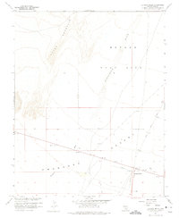
1961 Map of Lathrop Wells
USGS Topo · Published 1975About this map
Nevada Test Site lands dominate the eastern half of this 1961 survey, where the arid expanse of the Amargosa Desert meets the rising slopes of Yucca Mountain. The settlement of Lathrop Wells sits at a critical junction of desert travel, flanked by a primitive Airstrip and a network of jeep trails. This period reflects the high-intensity operations of the Atomic Energy Commission, as noted in the margin, which worked in cooperation with the USGS to map this sensitive terrain. Evidence of mineral exploration is scattered across the landscape in the form of several unnamed Prospects and a Gravel Pit. Natural water sources, precious in this environment, are represented by Cane Spring and a few isolated wells, while the dry path of Fortymile Wash cuts a wide swath through the valley floor, indicating the scale of occasional flash drainage.
Find a feature on this map
18 named features on this map. Tap any name to fly to it.
Don’t see what you’re looking for? This feature index may not catch every label — zoom into the map to look around manually.
Map Details
Editions of this 1961 Lathrop Wells Map
3 editions found
Other maps of this area

1908 · Furnace Creek
USGS Topo · 1:250,000

1910 · Furnace Creek
USGS Topo · 1:250,000

1942 · Skull Mountain
USGS Topo · 1:125,000

1942 · Bullfrog
USGS Topo · 1:125,000

1948 · Death Valley
USGS Topo · 1:250,000

1952 · Topopah Spring
USGS Topo · 1:62,500

1952 · Big Dune
USGS Topo · 1:62,500

1954 · Bare Mtn
USGS Topo · 1:62,500

1954 · Death Valley
USGS Topo · 1:250,000

1956 · Death Valley
USGS Topo · 1:250,000