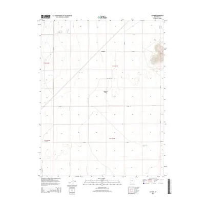
2014 Map of Latimer
USGS Topo · Published 2014About this map
The Escalante Desert dominates this section of Iron County, defined by its broad, arid basins and the subtle relief of volcanic features. The small settlement of Latimer sits at a crossroads of section-line roads, such as W 23200 N, within this vast desert landscape. Topographical interest is found to the northeast at Blue Knoll, where elevation lines tighten to mark a prominent height above the surrounding flats. Drainage patterns for the region are indicated by seasonal watercourses like Fishers Wash in the west and Mud Spring Wash to the southeast. The map details a network of desert roads and tracks, including the Lowe Well Loop and the Frost Rd Spur, which suggest the sparse but persistent human footprint of ranching or resource management in this open country.
Find a feature on this map
15 named features on this map. Tap any name to fly to it.
Don’t see what you’re looking for? This feature index may not catch every label — zoom into the map to look around manually.
Map Details
Editions of this 2014 Latimer Map
This is the sole edition of this map. No revisions or reprints were ever made.
Other maps of this area

1885 · St. George
USGS Topo · 1:250,000

1891 · St. George
USGS Topo · 1:250,000

1950 · Enoch
USGS Topo · 1:62,500

1951 · Avon
USGS Topo · 1:24,000

1951 · Avon NW
USGS Topo · 1:24,000
1952 · Enoch NW
USGS Topo · 1:24,000

1953 · Richfield
USGS Topo · 1:250,000

1953 · Cedar City
USGS Topo · 1:250,000

1958 · Richfield
USGS Topo · 1:250,000

1958 · Cedar City
USGS Topo · 1:250,000