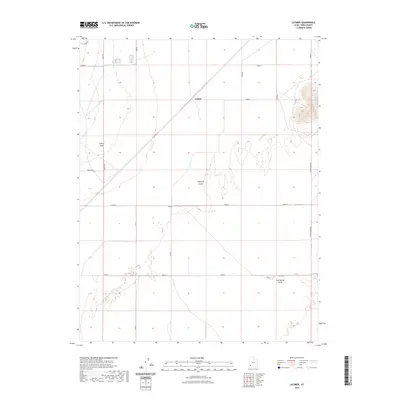
2023 Map of Latimer
USGS Topo · Published 2023About this map
Escalante Desert terrain dominates this Iron County landscape, where the arid environment of southern Utah is mapped in contemporary detail. The settlement of Latimer serves as a central reference point in an area defined by its drainage patterns and utilitarian infrastructure. Water management and access are essential in this high desert, evidenced by the presence of Lyman Well and seasonal watercourses such as Fishers Wash and Mud Spring Wash. The road network, including Schoppmann Rd and the appropriately named Frosty, illustrates the grid-like partitioning of the Lund Flats. This modern survey provides a clear view of how land use and transit corridors have evolved within the desert's expanse, offering a precise record of the topography and naming conventions used by the U.S. Geological Survey and other federal agencies in the early twenty-first century.
Find a feature on this map
9 named features on this map. Tap any name to fly to it.
Don’t see what you’re looking for? This feature index may not catch every label — zoom into the map to look around manually.
Map Details
Editions of this 2023 Latimer Map
This is the sole edition of this map. No revisions or reprints were ever made.
Other maps of this area

1885 · St. George
USGS Topo · 1:250,000

1891 · St. George
USGS Topo · 1:250,000

1950 · Enoch
USGS Topo · 1:62,500

1951 · Avon
USGS Topo · 1:24,000

1951 · Avon NW
USGS Topo · 1:24,000
1952 · Enoch NW
USGS Topo · 1:24,000

1953 · Richfield
USGS Topo · 1:250,000

1953 · Cedar City
USGS Topo · 1:250,000

1958 · Richfield
USGS Topo · 1:250,000

1958 · Cedar City
USGS Topo · 1:250,000