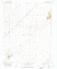
1971 Map of Latimer
USGS Topo · Published 1974About this map
Latimer appears as a small siding or stop along the Union Pacific railroad line as it cuts diagonally across the open expanse of the Escalante Desert. The landscape is defined by its water management infrastructure, where scattered features such as Lowe Well, Government Well, and a Water Tank indicate the vital necessity of tapping groundwater in this arid Iron County region. The terrain is largely flat, broken only by the prominent elevation of Blue Knoll and its associated Blue Knoll Well. Drainage patterns are visible through seasonal channels like Fishers Wash and Mud Spring Wash, which suggest the occasional flash floods typical of the desert environment. This survey provides a clear record of the relationship between industrial transportation and the survival of small desert settlements in the early 1970s.
Find a feature on this map
12 named features on this map. Tap any name to fly to it.
Don’t see what you’re looking for? This feature index may not catch every label — zoom into the map to look around manually.
Map Details
Editions of this 1971 Latimer Map
This is the sole edition of this map. No revisions or reprints were ever made.
Other maps of this area

1885 · St. George
USGS Topo · 1:250,000

1891 · St. George
USGS Topo · 1:250,000

1950 · Enoch
USGS Topo · 1:62,500

1951 · Avon
USGS Topo · 1:24,000

1951 · Avon NW
USGS Topo · 1:24,000
1952 · Enoch NW
USGS Topo · 1:24,000

1953 · Richfield
USGS Topo · 1:250,000

1953 · Cedar City
USGS Topo · 1:250,000

1958 · Richfield
USGS Topo · 1:250,000

1958 · Cedar City
USGS Topo · 1:250,000