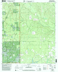
2000 Map of Latimer
USGS Topo · Published 2002About this map
De Soto National Forest lands dominate this coastal Mississippi landscape, where the settlement of Latimer is marked by a concentration of rural religious and family landmarks. The area's social history is recorded through sites like Bethel Hill Ch and the House of Prayer Tabernacle, alongside family grounds such as Wilkerson Cem and Seymour Cem. These features are connected by a network of timber and access roads, including Daisy-Vestry Road and Double Still Road, which navigate the subtle topography of Still Road Ridge.
Find a feature on this map
45 named features on this map. Tap any name to fly to it.
Don’t see what you’re looking for? This feature index may not catch every label — zoom into the map to look around manually.
Map Details
Editions of this 2000 Latimer Map
This is the sole edition of this map. No revisions or reprints were ever made.
Other maps of this area

1941 · Vancleave
USGS Topo · 1:62,500

1943 · Pascagoula
USGS Topo · 1:62,500

1943 · Vancleave
USGS Topo · 1:62,500

1944 · Vancleave
USGS Topo · 1:62,500

1953 · Mobile
USGS Topo · 1:250,000

1954 · Vestry
USGS Topo · 1:62,500

1954 · Ocean Springs
USGS Topo · 1:24,000

1954 · Biloxi
USGS Topo · 1:24,000

1954 · Biloxi
USGS Topo · 1:62,500

1955 · Pascagoula
USGS Topo · 1:62,500