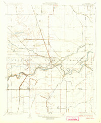
1927 Map of Laton
USGS Topo · Published 1927About this map
The Kings River divides the landscape of the Laguna de Tache in this 1920s survey, illustrating a complex hydraulic network of irrigation canals and natural waterways. The regional economy of the San Joaquin Valley is clearly visible through the engineered path of the Liberty Ditch, Riverside Ditch, and Peoples Ditch, which redirect water across the valley floor to support growing agricultural interests. Settlement patterns follow the steel of the Atchison Topeka and Santa Fe and Southern Pacific railroads, which anchor communities like Laton and Hardwick. The boundary between Fresno and Kings counties cuts across the river’s path, while rural life is marked by the presence of the Grant School and Kings River School. Local drainage and natural overflows are captured in the winding routes of Murphy Slough and Cole Slough, contrasting with the rigid grid of roads like Mt Whitney Avenue.
Find a feature on this map
29 named features on this map. Tap any name to fly to it.
Don’t see what you’re looking for? This feature index may not catch every label — zoom into the map to look around manually.
Map Details
Editions of this 1927 Laton Map
3 editions found
Other maps of this area

1924 · Riverdale
USGS Topo · 1:31,680

1924 · Selma
USGS Topo · 1:31,680

1924 · Conejo
USGS Topo · 1:31,680

1925 · Caruthers
USGS Topo · 1:31,680

1926 · Hanford
USGS Topo · 1:31,680

1926 · Burris Park
USGS Topo · 1:31,680

1927 · Laton
USGS Topo · 1:31,680

1927 · Remnoy
USGS Topo · 1:31,680

1927 · Riverdale
USGS Topo · 1:31,680

1927 · Lemoore
USGS Topo · 1:31,680