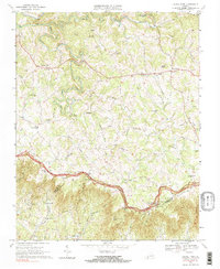
1968 Map of Laurel Fork
USGS Topo · Published 1985About this map
Big Reed Island Creek and its many winding tributaries like Sulphur Spring Br and Potters Br define this high-country landscape along the border of Carroll and Patrick counties. This 1968 field survey shows a rural mountain economy organized around the Blue Ridge Parkway, which traces the crest of the Blue Ridge through the southern portion of the sheet. The settlement patterns are typical of the era, with small communities like Gladesboro and Laurel Fork serving as local hubs, each supporting numerous small houses of worship including the Blue Ridge Tabernacle, New Fellowship Ch, and Crooked Oak Ch. For genealogists and local historians, the map is remarkably dense with unnamed cemeteries and family landmarks like Jackson Knob, Branscomb Hill, and Gibson Knob. The presence of the Laurel Fork Sch and a Lookout Tower near Groundhog Mtn suggests a landscape of active forest management and established rural education during the late 1960s.
Find a feature on this map
49 named features on this map. Tap any name to fly to it.
Don’t see what you’re looking for? This feature index may not catch every label — zoom into the map to look around manually.
Map Details
Editions of this 1968 Laurel Fork Map
Other maps of this area

1889 · Hillsville
USGS Topo · 1:125,000

1892 · Hillsville
USGS Topo · 1:125,000

1896 · Hillsville
USGS Topo · 1:125,000

1928 · Stuart
USGS Topo · 1:48,000

1931 · Stuart
USGS Topo · 1:62,500

1953 · Winston-Salem
USGS Topo · 1:250,000

1955 · Winston-Salem
USGS Topo · 1:250,000

1956 · Macks Mountain
USGS Topo · 1:62,500

1957 · Mount Airy
USGS Topo · 1:62,500

1957 · Floyd
USGS Topo · 1:62,500