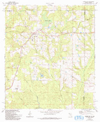
1973 Map of Laurel Hill
USGS Topo · Published 1993About this map
The Louisville and Nashville railroad corridor anchors this survey of northern Okaloosa County, passing through the town of Laurel Hill and the smaller settlements of Svea and Okaloo. The landscape is defined by a dense network of water features, including named bays and heads like Watson Bay, Ward Bay, and Black Gum Head, which signal the unique hydrology of the Florida-Alabama borderlands. Genealogists will find significant value in the distribution of community landmarks, from Rock Hill Cem in the south to a cluster of rural houses of worship including Mt Zion Ch, Travelers Rest Ch, and Mt Lucas Ch. The map illustrates a transitional period in the early 1970s where traditional land use, evidenced by Campbells Mill Creek, met modern infrastructure like the prominent Lookout Tower.
Find a feature on this map
36 named features on this map. Tap any name to fly to it.
Don’t see what you’re looking for? This feature index may not catch every label — zoom into the map to look around manually.
Map Details
Editions of this 1973 Laurel Hill Map
2 editions found
Other maps of this area

1949 · Crestview
USGS Topo · 1:62,500

1949 · Laurel Hill
USGS Topo · 1:62,500

1950 · Laurel Hill
USGS Topo · 1:62,500

1951 · Crestview
USGS Topo · 1:62,500

1953 · Andalusia
USGS Topo · 1:250,000

1957 · Andalusia
USGS Topo · 1:250,000

1957 · Pensacola
USGS Topo · 1:250,000

1959 · Pensacola
USGS Topo · 1:250,000

1960 · Pensacola
USGS Topo · 1:250,000

1971 · Wing
USGS Topo · 1:24,000