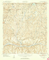
1950 Map of Laurel Hill
USGS Topo · Published 1950About this map
Laurel Hill serves as a central hub in this post-war landscape, situated where the Louisville and Nashville railroad cuts through the panhandle. The map captures a mid-century period of rural expansion and established community life, evidenced by a dense network of country churches like Bethel Ch and Rock Hill Ch. Along the southern edge, the Old Spanish Trail follows the course of the Shoal River, marking a historic transportation corridor that predates modern highways. To the north, the terrain transitions into the Conecuh National Forest, crossing the state line into Alabama. Genealogists will find significant value in the numerous burial sites and small settlements, including Old Dorcas Cem and the remote Pennywinkle Sch, which together suggest a pattern of dispersed homesteads and small-scale farming near the Covington and Okaloosa County line.
Find a feature on this map
105 named features on this map. Tap any name to fly to it.
Don’t see what you’re looking for? This feature index may not catch every label — zoom into the map to look around manually.
Map Details
Editions of this 1950 Laurel Hill Map
2 editions found
Other maps of this area

1934 · Holt
USGS Topo · 1:48,000

1934 · Niceville
USGS Topo · 1:48,000

1935 · De Funiak Springs
USGS Topo · 1:48,000

1936 · Niceville
USGS Topo · 1:62,500

1937 · Holt
USGS Topo · 1:62,500

1938 · De Funiak Springs
USGS Topo · 1:62,500

1949 · Glendale
USGS Topo · 1:62,500

1949 · Crestview
USGS Topo · 1:62,500

1949 · Laurel Hill
USGS Topo · 1:62,500

1950 · Laurel Hill
USGS Topo · 1:62,500