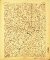
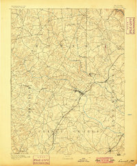
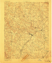
1894 Map of Laurel
USGS Topo · Published 1905About this map
Laurel serves as the central hub of this late-19th-century landscape, positioned where the Baltimore and Ohio Railroad meets the Patuxent River. The map reveals a corridor of early industrial and transit activity, marked by numerous Iron Ore deposits and historic depots such as Annapolis Junc. and Savage Sta.. Settlement patterns are dictated by the river valleys, with clusters of activity at Oakland Mills and Guilford along the Middle Patuxent River.
Find a feature on this map
55 named features on this map. Tap any name to fly to it.
Don’t see what you’re looking for? This feature index may not catch every label — zoom into the map to look around manually.
Map Details
Editions of this 1894 Laurel Map
4 editions found
Other maps of this area

1890 · Mt. Vernon
USGS Topo · 1:125,000

1891 · Mt. Vernon
USGS Topo · 1:125,000

1892 · Laurel
USGS Topo · 1:62,500

1892 · Ellicott
USGS Topo · 1:62,500

1892 · Owensville
USGS Topo · 1:62,500

1893 · Frederick
USGS Topo · 1:125,000

1894 · Ellicott
USGS Topo · 1:62,500

1894 · Laurel
USGS Topo · 1:62,500

1894 · Baltimore
USGS Topo · 1:62,500

1894 · Frederick
USGS Topo · 1:125,000