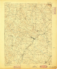
1894 Map of Laurel
USGS Topo · Published 1899About this map
Baltimore and Ohio RR tracks cut a diagonal path across the landscape, anchoring several industrial and transit points in the corridor between Washington and Baltimore. The presence of multiple Iron Ore labels near Muirkirk, Contee, and Buxton reveals the region’s active mining heritage at the end of the nineteenth century. These deposits supported local furnaces, while the Patuxent River and its branches—the Middle Patuxent River and Little Patuxent River—provided the necessary water power for settlements like Savage and Oakland Mills.
Find a feature on this map
54 named features on this map. Tap any name to fly to it.
Don’t see what you’re looking for? This feature index may not catch every label — zoom into the map to look around manually.
Map Details
Editions of this 1894 Laurel Map
4 editions found
Other maps of this area

1890 · Mt. Vernon
USGS Topo · 1:125,000

1891 · Mt. Vernon
USGS Topo · 1:125,000

1892 · Laurel
USGS Topo · 1:62,500

1892 · Ellicott
USGS Topo · 1:62,500

1892 · Owensville
USGS Topo · 1:62,500

1893 · Frederick
USGS Topo · 1:125,000

1894 · Ellicott
USGS Topo · 1:62,500

1894 · Laurel
USGS Topo · 1:62,500

1894 · Baltimore
USGS Topo · 1:62,500

1894 · Frederick
USGS Topo · 1:125,000