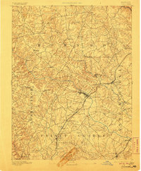
1894 Map of Laurel
USGS Topo · Published 1906About this map
Patuxent River drainage basins and the industrial corridors of the late 19th century define this landscape at the intersection of Howard, Anne Arundel, Montgomery, and Prince George counties. A significant corridor of Iron Ore pits follows the Baltimore and Ohio Railroad between Muirkirk and Contee, highlighting the region's mineral extraction history. The map detail reflects a transition from rural milling sites like Oakland Mills and Savage to emerging rail hubs such as Annapolis Junc. The presence of Snell Bridge and Brown Bridge provides specific points for tracing historic road alignments across the major river forks. Major institutional and social landmarks include College, Ammendale, and a Hotel near Oak Crest, illustrating the early development patterns of the Laurel area before modern suburbanization. These labels offer genealogists and historians a look at localized settlements such as Wesley Grove and Highland during a period of rail-driven growth.
Find a feature on this map
54 named features on this map. Tap any name to fly to it.
Don’t see what you’re looking for? This feature index may not catch every label — zoom into the map to look around manually.
Map Details
Editions of this 1894 Laurel Map
4 editions found
Other maps of this area

1890 · Mt. Vernon
USGS Topo · 1:125,000

1891 · Mt. Vernon
USGS Topo · 1:125,000

1892 · Laurel
USGS Topo · 1:62,500

1892 · Ellicott
USGS Topo · 1:62,500

1892 · Owensville
USGS Topo · 1:62,500

1893 · Frederick
USGS Topo · 1:125,000

1894 · Ellicott
USGS Topo · 1:62,500

1894 · Laurel
USGS Topo · 1:62,500

1894 · Baltimore
USGS Topo · 1:62,500

1894 · Frederick
USGS Topo · 1:125,000