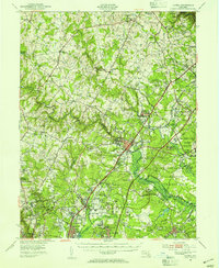
1949 Map of Laurel
USGS Topo · Published 1954About this map
The Middle Patuxent River and Little Patuxent River converge near Savage, where the landscape is defined by the heavy footprint of mid-century government and institutional growth. The extensive Fort George G Meade Military Reservation dominates the eastern section, while the sprawling Beltsville Research Center and the Ordnance Laboratory reflect the region's increasing importance to federal science and defense. This 1949 survey captures the transition of Howard and Prince George’s counties from a network of small crossroads like Scaggsville and Vansville into a critical corridor of specialized infrastructure.
Find a feature on this map
107 named features on this map. Tap any name to fly to it.
Don’t see what you’re looking for? This feature index may not catch every label — zoom into the map to look around manually.
Map Details
Editions of this 1949 Laurel Map
2 editions found
Other maps of this area

1890 · Mt. Vernon
USGS Topo · 1:125,000

1891 · Mt. Vernon
USGS Topo · 1:125,000

1892 · Laurel
USGS Topo · 1:62,500

1892 · Ellicott
USGS Topo · 1:62,500

1892 · Owensville
USGS Topo · 1:62,500

1893 · Frederick
USGS Topo · 1:125,000

1894 · Ellicott
USGS Topo · 1:62,500

1894 · Laurel
USGS Topo · 1:62,500

1894 · Baltimore
USGS Topo · 1:62,500

1894 · Frederick
USGS Topo · 1:125,000