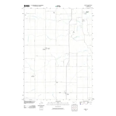
2010 Map of Laurel
USGS Topo · Published 2010About this map
Laurel and Haverhill anchor this rural landscape in Marshall County, which is defined by a grid of section roads and several branches of Timber Creek. The terrain is partitioned by North Timber Creek, Middle Timber Creek, and South Timber Creek, creating a series of drainages that dictate the placement of farms and small settlements. Local history is deeply rooted in the numerous denominational and community burying grounds found here, including the Immaculate Conception Cemetery near Haverhill and the Saint John's United Church of Christ Cemetery further south.
Find a feature on this map
46 named features on this map. Tap any name to fly to it.
Don’t see what you’re looking for? This feature index may not catch every label — zoom into the map to look around manually.
Map Details
Editions of this 2010 Laurel Map
This is the sole edition of this map. No revisions or reprints were ever made.
Other maps of this area

1954 · Waterloo
USGS Topo · 1:250,000

1954 · Des Moines
USGS Topo · 1:250,000

1955 · Waterloo
USGS Topo · 1:250,000

1956 · Des Moines
USGS Topo · 1:250,000

1957 · Des Moines
USGS Topo · 1:250,000

1960 · Marshalltown
USGS Topo · 1:24,000

1960 · Marshalltown
USGS Topo · 1:62,500

1960 · Le Grand
USGS Topo · 1:24,000

1969 · Des Moines
USGS Topo · 1:250,000
1975 · Melbourne
USGS Topo · 1:24,000