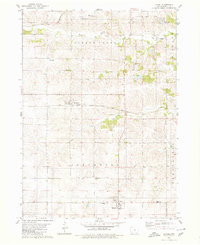
1980 Map of Laurel
USGS Topo · Published 1980About this map
The agrarian landscape of Jefferson and Greene townships is defined by the branching tributaries of Timber Creek, which carve through the Iowa countryside south of the Marshalltown corporation boundary. At this time in the late 1970s, the rail network shows a transition in progress, featuring the active Chicago and North Western line passing through Luray while the Chicago Milwaukee St Paul and Pacific Railroad Grade is noted through Haverhill. Local history is preserved in a dense network of rural burial sites and landmarks, including the Immaculate Conception Cem (St John Ch) and the Methodist Cem. The town of Laurel serves as a southern anchor for the quadrangle, positioned near the Graceland Cem and the local Waterworks, illustrating a stable pattern of mid-century Midwestern settlement and infrastructure.
Find a feature on this map
26 named features on this map. Tap any name to fly to it.
Don’t see what you’re looking for? This feature index may not catch every label — zoom into the map to look around manually.
Map Details
Editions of this 1980 Laurel Map
This is the sole edition of this map. No revisions or reprints were ever made.
Other maps of this area

1954 · Waterloo
USGS Topo · 1:250,000

1954 · Des Moines
USGS Topo · 1:250,000

1955 · Waterloo
USGS Topo · 1:250,000

1956 · Des Moines
USGS Topo · 1:250,000

1957 · Des Moines
USGS Topo · 1:250,000

1960 · Marshalltown
USGS Topo · 1:24,000

1960 · Marshalltown
USGS Topo · 1:62,500

1960 · Le Grand
USGS Topo · 1:24,000

1969 · Des Moines
USGS Topo · 1:250,000
1975 · Melbourne
USGS Topo · 1:24,000