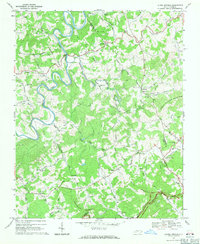
1968 Map of Laurel Springs
USGS Topo · Published 1971About this map
The South Fork New River carves a winding path through the high country of the Blue Ridge, serving as a geographic anchor for the rural communities of Ashe and Alleghany Counties in the late 1960s. This survey illustrates a landscape defined by its network of country churches, including Liberty Hill Ch, New Hope Ch, and Mt Zion Church, which acted as local hubs for the surrounding farmsteads. The terrain rises sharply from the river valley toward prominent peaks such as Peach Bottom Mountain and Franks Knob, while the Parkway skirts the southern edge of the quadrangle. Small settlements like Scottville, Furches, and Laurel Springs are connected by narrow roads such as Hoke Wagoner Road, tracing the drainage patterns of Cranberry Creek and Nathans Creek. A single Quarry and the landmark Ore Knob suggest the area's geological and industrial history amidst its predominantly agricultural character.
Find a feature on this map
63 named features on this map. Tap any name to fly to it.
Don’t see what you’re looking for? This feature index may not catch every label — zoom into the map to look around manually.
Map Details
Editions of this 1968 Laurel Springs Map
2 editions found
Other maps of this area

1889 · Wytheville
USGS Topo · 1:125,000

1889 · Wilkesboro
USGS Topo · 1:125,000

1891 · Wilkesboro
USGS Topo · 1:125,000

1892 · Wytheville
USGS Topo · 1:125,000

1930 · Independence
USGS Topo · 1:48,000

1933 · Independence
USGS Topo · 1:62,500

1935 · Mouth of Wilson
USGS Topo · 1:48,000

1940 · Mouth of Wilson
USGS Topo · 1:62,500

1953 · Winston-Salem
USGS Topo · 1:250,000

1955 · Winston-Salem
USGS Topo · 1:250,000