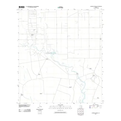
2010 Map of Laureles Ranch
USGS Topo · Published 2010About this map
Petronila Creek meanders through this South Texas landscape, defined by a distinct transition between industrial oil production and traditional ranching operations. The northern portion of the quadrangle is anchored by the Luby Oil Field and the Stanolind-Luby Camp Refinery, illustrating the energy infrastructure vital to the region. To the south and east, the map reveals a pattern of large-scale landholdings including the Santa Cruz Ranch and Laureles Ranch. A network of water management and livestock infrastructure is evident, from the Chapman Ranch Lake Dam to a series of named water-pumping landmarks such as the Noria Dan Windmill, Falcon Windmill, and Don Roberto Windmill. These features indicate the specialized engineering required to sustain ranching across the arid plains of Nueces County.
Find a feature on this map
29 named features on this map. Tap any name to fly to it.
Don’t see what you’re looking for? This feature index may not catch every label — zoom into the map to look around manually.
Map Details
Editions of this 2010 Laureles Ranch Map
This is the sole edition of this map. No revisions or reprints were ever made.
Other maps of this area

1924 · Petronilla
USGS Topo · 1:62,500

1925 · Oso Creek
USGS Topo · 1:62,500

1928 · Sarita
USGS Topo · 1:125,000

1950 · Corpus Christi
USGS Topo · 1:250,000

1951 · South Bird Island NW
USGS Topo · 1:24,000

1951 · Oso Creek NW
USGS Topo · 1:24,000

1951 · Riviera Beach NE
USGS Topo · 1:24,000

1951 · Oso Creek
USGS Topo · 1:62,500

1951 · South Bird Island
USGS Topo · 1:62,500

1952 · Riviera Beach NW
USGS Topo · 1:24,000