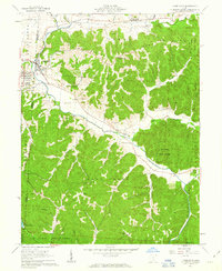
1961 Map of Laurelville
USGS Topo · Published 1963About this map
The hills of Hocking and Pickaway counties converge at Laurelville and Adelphi, where the flat valley of Salt Creek meets the steep, wooded terrain of Dumm Ridge. This early 1960s survey documents a landscape defined by sharp elevation changes and narrow hollows, such as Carney Hollow and Pike Hollow, which dictate the placement of rural settlements and winding roads. Local history is anchored by several country churches, including Salt Creek Valley Ch and Mt Carmel Ch, alongside family burial grounds like Davis Cem and Berry Cem.
Find a feature on this map
47 named features on this map. Tap any name to fly to it.
Don’t see what you’re looking for? This feature index may not catch every label — zoom into the map to look around manually.
Map Details
Editions of this 1961 Laurelville Map
4 editions found
Other maps of this area

1906 · Chillicothe
USGS Topo · 1:62,500

1907 · Lancaster
USGS Topo · 1:62,500

1908 · Chillicothe
USGS Topo · 1:62,500

1909 · Lancaster
USGS Topo · 1:62,500

1910 · Laurelville
USGS Topo · 1:62,500

1912 · Laurelville
USGS Topo · 1:62,500

1914 · Circleville
USGS Topo · 1:62,500

1943 · Circleville
USGS Topo · 1:62,500

1944 · Laurelville
USGS Topo · 1:62,500

1947 · Columbus
USGS Topo · 1:250,000