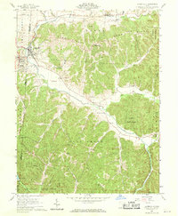
1961 Map of Laurelville
USGS Topo · Published 1970About this map
Salt Creek winds through a landscape defined by the intersection of four counties, anchoring the communities of Laurelville and Adelphi during the early 1960s. The map reveals a rural economy transitioning from early industry to conservation, with several Gravel Pits located near the town centers while vast acreage is dedicated to the Hocking State Forest and Tar Hollow State Forest. This period of Hocking County history is remarkably well-documented for genealogists through the presence of numerous family and community burial grounds, including Haynes Cem, Perry Cem, and Scholey Cem.
Find a feature on this map
52 named features on this map. Tap any name to fly to it.
Don’t see what you’re looking for? This feature index may not catch every label — zoom into the map to look around manually.
Map Details
Editions of this 1961 Laurelville Map
4 editions found
Other maps of this area

1906 · Chillicothe
USGS Topo · 1:62,500

1907 · Lancaster
USGS Topo · 1:62,500

1908 · Chillicothe
USGS Topo · 1:62,500

1909 · Lancaster
USGS Topo · 1:62,500

1910 · Laurelville
USGS Topo · 1:62,500

1912 · Laurelville
USGS Topo · 1:62,500

1914 · Circleville
USGS Topo · 1:62,500

1943 · Circleville
USGS Topo · 1:62,500

1944 · Laurelville
USGS Topo · 1:62,500

1947 · Columbus
USGS Topo · 1:250,000