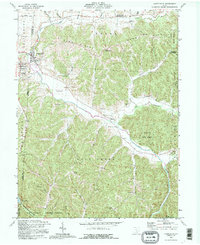
1992 Map of Laurelville
USGS Topo · Published 1995About this map
Salt Creek defines the local topography of this 1990s-era map, carving a winding path through the intersection of Hocking, Pickaway, Ross, and Vinton Counties. The village of Laurelville sits near the confluence of Laurel Run and Salt Creek, serving as a primary settlement alongside neighboring Adelphi. The landscape is notably dominated by the wooded ridges of Hocking State Forest and the southern reaches of Tar Hollow State Park, where Pine Lake and its gaging station are located. Genealogists and local historians will find numerous family-named landmarks and rural burial grounds, such as Friend Cem, Haynes Cem, and Schooley Cem, often associated with country churches like the Salt Creek Valley Ch. Cultural history is further represented by an Indian Mound located south of the California Branch, suggesting long-standing human occupation in this creek-veined valley system.
Find a feature on this map
60 named features on this map. Tap any name to fly to it.
Don’t see what you’re looking for? This feature index may not catch every label — zoom into the map to look around manually.
Map Details
Editions of this 1992 Laurelville Map
This is the sole edition of this map. No revisions or reprints were ever made.
Other maps of this area

1906 · Chillicothe
USGS Topo · 1:62,500

1907 · Lancaster
USGS Topo · 1:62,500

1908 · Chillicothe
USGS Topo · 1:62,500

1909 · Lancaster
USGS Topo · 1:62,500

1910 · Laurelville
USGS Topo · 1:62,500

1912 · Laurelville
USGS Topo · 1:62,500

1914 · Circleville
USGS Topo · 1:62,500

1943 · Circleville
USGS Topo · 1:62,500

1944 · Laurelville
USGS Topo · 1:62,500

1947 · Columbus
USGS Topo · 1:250,000