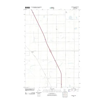
2010 Map of Lawndale
USGS Topo · Published 2010About this map
Lawndale sits at the junction of County Hwy-52 and several rural routes in this section of Wilkin County. The landscape is defined by the winding course of the South Branch Buffalo River and its tributary, Deerhorn Creek, which cut through the agricultural grid. This 2010 survey illustrates the persistence of early prairie settlements through their well-preserved burial grounds, specifically Little Bethany Cemetery in the northeast and Prairie View Cemetery further south. The transportation network is a mix of state and county thoroughfares, including County Hwy-32 and County Hwy-188, connecting various farmsteads and rural properties. Local history researchers can trace the precise boundaries of land plots and the evolution of the road system from early township tracks to modern paved highways.
Find a feature on this map
32 named features on this map. Tap any name to fly to it.
Don’t see what you’re looking for? This feature index may not catch every label — zoom into the map to look around manually.
Map Details
Editions of this 2010 Lawndale Map
This is the sole edition of this map. No revisions or reprints were ever made.
Other maps of this area

1913 · Fergus Falls
USGS Topo · 1:62,500

1914 · Pelican Rapids
USGS Topo · 1:62,500

1917 · Pelican Rapids
USGS Topo · 1:62,500

1919 · Rothsay
USGS Topo · 1:62,500

1919 · Barnesville
USGS Topo · 1:62,500

1951 · Rothsay
USGS Topo · 1:62,500

1952 · Barnesville
USGS Topo · 1:62,500

1953 · Fargo
USGS Topo · 1:250,000

1956 · Fargo
USGS Topo · 1:250,000
1973 · Lake Olaf
USGS Topo · 1:24,000