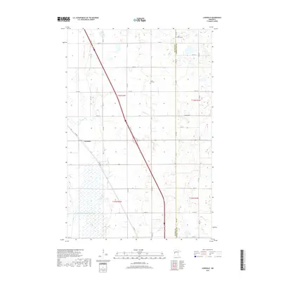
2019 Map of Lawndale
USGS Topo · Published 2019About this map
Lawndale stands at the center of this agricultural landscape in Wilkin County, positioned where Co Hwy 52 crosses the path of a major transportation corridor. The map reflects a meticulously planned rural grid, defined by township lines like t136n r45w and county boundaries separating Wilkin and Otter Tail Counties. Water management is a primary feature of the terrain, seen in the winding course of Deerhorn Cr and the engineered precision of Judicial Ditch Number Three-Two, which drains the lower-lying areas including Lawndale Swamp. Local heritage is anchored by quiet landmarks such as Little Bethany Cem in the north and Prairie View Cem further south, serving as permanent records of the families who settled this prairie region.
Find a feature on this map
29 named features on this map. Tap any name to fly to it.
Don’t see what you’re looking for? This feature index may not catch every label — zoom into the map to look around manually.
Map Details
Editions of this 2019 Lawndale Map
This is the sole edition of this map. No revisions or reprints were ever made.
Other maps of this area

1913 · Fergus Falls
USGS Topo · 1:62,500

1914 · Pelican Rapids
USGS Topo · 1:62,500

1917 · Pelican Rapids
USGS Topo · 1:62,500

1919 · Rothsay
USGS Topo · 1:62,500

1919 · Barnesville
USGS Topo · 1:62,500

1951 · Rothsay
USGS Topo · 1:62,500

1952 · Barnesville
USGS Topo · 1:62,500

1953 · Fargo
USGS Topo · 1:250,000

1956 · Fargo
USGS Topo · 1:250,000
1973 · Lake Olaf
USGS Topo · 1:24,000