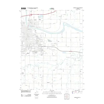
2012 Map of Lawrence East
USGS Topo · Published 2012About this map
Haskell Indian Nations Univ and the eastern reaches of the Univ Of Kansas - Lawrence campus anchor this landscape at the confluence of the Kansas River and Wakarusa River valleys. The urban grid of Lawrence transitions into the rural hills of Douglas County, marked by several prominent burial grounds including Oak Hill Cem and Memorial Park Cem. To the south, the terrain rises toward Blue Mound, overlooking the winding Wakarusa River where historical points like Wakarusa Crossing and Blue Jacket Crossing suggest long-established river passages. The eastern industrial and agricultural corridor is served by the BNSF Railway, passing through the small community of Noria. Farther south, the settlement of Sibleyville and the Bland Airport sit among the tributaries of Coal Cr and Spring Cr.
Find a feature on this map
161 named features on this map. Tap any name to fly to it.
Don’t see what you’re looking for? This feature index may not catch every label — zoom into the map to look around manually.
Map Details
Editions of this 2012 Lawrence East Map
This is the sole edition of this map. No revisions or reprints were ever made.
Other maps of this area

1885 · Lawrence
USGS Topo · 1:125,000

1886 · Oskaloosa
USGS Topo · 1:125,000

1888 · Oskaloosa
USGS Topo · 1:125,000

1889 · Lawrence
USGS Topo · 1:125,000

1894 · Oskaloosa
USGS Topo · 1:125,000

1947 · Lawrence
USGS Topo · 1:250,000

1949 · Williamstown
USGS Topo · 1:24,000

1950 · Kansas City
USGS Topo · 1:250,000

1950 · Williamstown
USGS Topo · 1:24,000

1950 · Lawrence
USGS Topo · 1:250,000