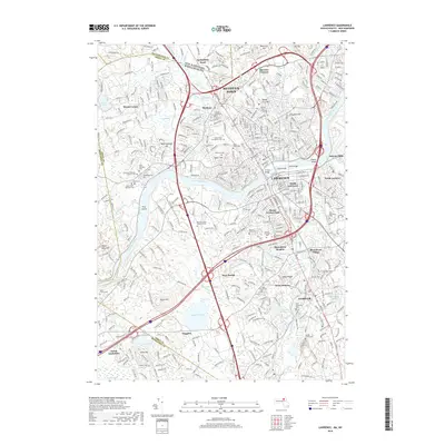
2018 Map of Lawrence
USGS Topo · Published 2018About this map
The Merrimack River flows through the heart of this industrial landscape, serving as the historical backbone for Lawrence and its surrounding textile-era neighborhoods. This contemporary survey details the urban density from South Lawrence to Methuen Town, while also highlighting the residential character of Shawsheen Village and North Andover. For those interested in local history and genealogy, the map identifies a high concentration of religious landmarks and burial grounds, including the Polish Cem, Lithuanian National Catholic Cem, and Sons of Israel Cem. Beyond the city centers, the terrain transitions into the hills and water bodies that shaped early development, such as Nickel Mine Hill, Haggetts Pond, and the rolling Indian Ridge. The map also traces modern infrastructure, including the O'Reilly Bridge and Duck Bridge, which connect the river's banks.
Find a feature on this map
75 named features on this map. Tap any name to fly to it.
Don’t see what you’re looking for? This feature index may not catch every label — zoom into the map to look around manually.
Map Details
Editions of this 2018 Lawrence Map
This is the sole edition of this map. No revisions or reprints were ever made.
Other maps of this area

1886 · Lawrence
USGS Topo · 1:62,500

1886 · Lowell
USGS Topo · 1:62,500

1888 · Haverhill
USGS Topo · 1:62,500

1888 · Lawrence
USGS Topo · 1:62,500

1890 · Haverhill
USGS Topo · 1:62,500

1893 · Lowell
USGS Topo · 1:62,500

1893 · Lawrence
USGS Topo · 1:62,500

1893 · Haverhill
USGS Topo · 1:62,500

1905 · Manchester
USGS Topo · 1:62,500

1918 · Lowell
USGS Topo · 1:62,500