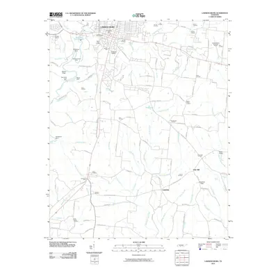
2010 Map of Lawrenceburg
USGS Topo · Published 2010About this map
Lawrenceburg serves as the focal point of this landscape, where the waters of Shoal Creek are managed by the New Shoal Creek Dam and its predecessor, the Old Shoal Creek Dam. The area's agricultural and industrial heritage is represented by Garner Mill and the numerous small watercourses like Turkey Creek and Fourmile Branch that thread through the terrain. Evidence of the region's long-established community structure is visible in the dense concentration of family and community burial grounds, ranging from the large Lawrenceburg City Cemetery and Mimosa Cemetery to more localized sites such as Bumpass Cemetery and Gum Springs Cemetery.
Find a feature on this map
116 named features on this map. Tap any name to fly to it.
Don’t see what you’re looking for? This feature index may not catch every label — zoom into the map to look around manually.
Map Details
Editions of this 2010 Lawrenceburg Map
This is the sole edition of this map. No revisions or reprints were ever made.
Other maps of this area

1936 · Deerfield
USGS Topo · 1:24,000

1936 · Campbellsville
USGS Topo · 1:24,000

1936 · Lawrenceburg
USGS Topo · 1:24,000

1936 · Ethridge
USGS Topo · 1:24,000

1936 · Long Branch
USGS Topo · 1:24,000

1936 · Loretto
USGS Topo · 1:24,000

1936 · Bodenham
USGS Topo · 1:24,000

1936 · Appleton
USGS Topo · 1:24,000

1936 · Bonnertown
USGS Topo · 1:24,000
1948 · Appleton
USGS Topo · 1:24,000