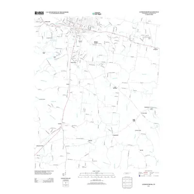
2013 Map of Lawrenceburg
USGS Topo · Published 2013About this map
Shoal Creek and its many tributaries, including Crouson Creek and Beeler Fork, define the landscape of south-central Tennessee in this 2013 survey. The city of Lawrenceburg extends its street grid southward toward Hickory Heights and Whiteoak Hollow, while the surrounding rural landscape is dotted with smaller communities like Leoma, Antioch, and Revilo. Water remains a central theme, from the New Shoal Creek Reservoir to family-named landmarks like Moore Spring and Glen Spring. Local industry and commerce are evident in sites like Garner Mill and the Sherrell Poultry Farms, as well as the Lawrenceburg-Lawrence County Airport on the northeastern edge. Long-established crossroads such as Dunn, Gum Springs, and Oak Hill anchor the agricultural regions between the ridges, while geographical markers like Wildcat Ridge and Raven Bluff rise above the creek bottoms.
Find a feature on this map
257 named features on this map. Tap any name to fly to it.
Don’t see what you’re looking for? This feature index may not catch every label — zoom into the map to look around manually.
Map Details
Editions of this 2013 Lawrenceburg Map
This is the sole edition of this map. No revisions or reprints were ever made.
Other maps of this area

1936 · Deerfield
USGS Topo · 1:24,000

1936 · Campbellsville
USGS Topo · 1:24,000

1936 · Lawrenceburg
USGS Topo · 1:24,000

1936 · Ethridge
USGS Topo · 1:24,000

1936 · Long Branch
USGS Topo · 1:24,000

1936 · Loretto
USGS Topo · 1:24,000

1936 · Bodenham
USGS Topo · 1:24,000

1936 · Appleton
USGS Topo · 1:24,000

1936 · Bonnertown
USGS Topo · 1:24,000
1948 · Appleton
USGS Topo · 1:24,000