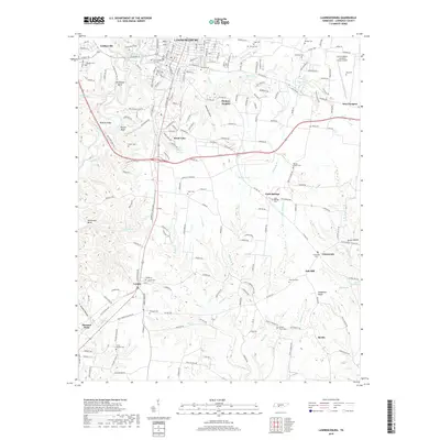
2019 Map of Lawrenceburg
USGS Topo · Published 2019About this map
The county seat of Lawrenceburg serves as the focal point of this Tennessee landscape, where the grid of city streets transitions into the rolling hills and creek bottoms of Lawrence County. Vital local history is preserved in numerous burial grounds, from the large Lawrenceburg City Cem and Mimosa Cem near the city center to smaller rural sites like Fuller Chapel Cem and Lindsey Grove Cem. The geography is defined by the winding course of Shoal Creek, which creates a dramatic Horseshoe Bend to the west.
Find a feature on this map
223 named features on this map. Tap any name to fly to it.
Don’t see what you’re looking for? This feature index may not catch every label — zoom into the map to look around manually.
Map Details
Editions of this 2019 Lawrenceburg Map
This is the sole edition of this map. No revisions or reprints were ever made.
Other maps of this area

1936 · Deerfield
USGS Topo · 1:24,000

1936 · Campbellsville
USGS Topo · 1:24,000

1936 · Lawrenceburg
USGS Topo · 1:24,000

1936 · Ethridge
USGS Topo · 1:24,000

1936 · Long Branch
USGS Topo · 1:24,000

1936 · Loretto
USGS Topo · 1:24,000

1936 · Bodenham
USGS Topo · 1:24,000

1936 · Appleton
USGS Topo · 1:24,000

1936 · Bonnertown
USGS Topo · 1:24,000
1948 · Appleton
USGS Topo · 1:24,000