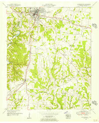
1951 Map of Lawrenceburg
USGS Topo · Published 1956About this map
Lawrenceburg serves as the focal point of this mid-century landscape, where the Louisville And Nashville railroad and the Nashville Highway converge to form a regional transportation hub. The surrounding countryside is deeply etched by the meandering course of Shoal Creek, which carves through the terrain near Wildcat Ridge and Horseshoe Bend. This 1951 record shows a rural economy structured around a dense network of small settlements and family-named landmarks, such as Gaitherville, Leoma, and Gum Springs. The map is particularly useful for genealogical research, documenting numerous community anchors including the Mimosa Cem, Dunn Sch, and the Lawrenceburg Power Plant situated along the creek. The distribution of cemeteries like Bumpass Cem and Shaw Cem alongside country churches such as Wesley Chapel reflects the established social fabric of Lawrence County before significant modern suburban expansion.
Find a feature on this map
48 named features on this map. Tap any name to fly to it.
Don’t see what you’re looking for? This feature index may not catch every label — zoom into the map to look around manually.
Map Details
Editions of this 1951 Lawrenceburg Map
This is the sole edition of this map. No revisions or reprints were ever made.
Other maps of this area

1936 · Deerfield
USGS Topo · 1:24,000

1936 · Campbellsville
USGS Topo · 1:24,000

1936 · Lawrenceburg
USGS Topo · 1:24,000

1936 · Ethridge
USGS Topo · 1:24,000

1936 · Long Branch
USGS Topo · 1:24,000

1936 · Loretto
USGS Topo · 1:24,000

1936 · Bodenham
USGS Topo · 1:24,000

1936 · Appleton
USGS Topo · 1:24,000

1936 · Bonnertown
USGS Topo · 1:24,000
1948 · Appleton
USGS Topo · 1:24,000