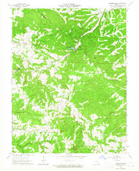
1964 Map of Lawrenceton
USGS Topo · Published 1965About this map
Lawrenceton sits at the heart of this mid-1960s landscape, positioned near the drainage of Fourche Du Clos and the waters of Pinkston Lake. The map reveals a deeply etched topography across the boundary of Ste. Genevieve and St. Francois counties, where narrow ridges like Pinhook Ridge separate numerous winding creek valleys. This area reflects a traditional rural Missouri settlement pattern, with family identity tied closely to the land through numerous small burial grounds, including the Patterson Cem, Bequette Cem, and Jennings Cem. Economic and social life is anchored by landmarks such as the Little Vine Ch and a prominent Lookout Tower, while a Quarry in the northwest indicates the local extraction of stone. The network of unimproved roads and state routes like Ee and C connect these dispersed hill-country features.
Find a feature on this map
27 named features on this map. Tap any name to fly to it.
Don’t see what you’re looking for? This feature index may not catch every label — zoom into the map to look around manually.
Map Details
Editions of this 1964 Lawrenceton Map
3 editions found
Other maps of this area

1904 · Farmington
USGS Topo · 1:62,500

1906 · Farmington
USGS Topo · 1:62,500

1907 · Weingarten
USGS Topo · 1:62,500

1909 · Weingarten
USGS Topo · 1:62,500

1915 · Renault
USGS Topo · 1:62,500

1915 · Crystal City
USGS Topo · 1:62,500

1940 · Renault
USGS Topo · 1:62,500

1949 · Saint Louis
USGS Topo · 1:250,000

1949 · Rolla
USGS Topo · 1:250,000

1949 · Crystal City
USGS Topo · 1:62,500