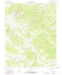
1964 Map of Lawrenceton
USGS Topo · Published 1982About this map
Lawrenceton sits at the heart of this mid-century landscape, positioned near the winding waters of Fourche Du Clos in a region defined by its prominent ridges and hollows. The area, spanning the border of Ste. Genevieve and St. Francois counties, reveals a traditional rural settlement pattern centered on community landmarks like Little Vine Ch. The terrain is marked by significant features such as Pinhook Ridge and Seiben Bottom H, while the presence of a Lookout Tower suggests the importance of forest management in these wooded uplands during the early 1960s.
Find a feature on this map
26 named features on this map. Tap any name to fly to it.
Don’t see what you’re looking for? This feature index may not catch every label — zoom into the map to look around manually.
Map Details
Editions of this 1964 Lawrenceton Map
3 editions found
Other maps of this area

1904 · Farmington
USGS Topo · 1:62,500

1906 · Farmington
USGS Topo · 1:62,500

1907 · Weingarten
USGS Topo · 1:62,500

1909 · Weingarten
USGS Topo · 1:62,500

1915 · Renault
USGS Topo · 1:62,500

1915 · Crystal City
USGS Topo · 1:62,500

1940 · Renault
USGS Topo · 1:62,500

1949 · Saint Louis
USGS Topo · 1:250,000

1949 · Rolla
USGS Topo · 1:250,000

1949 · Crystal City
USGS Topo · 1:62,500