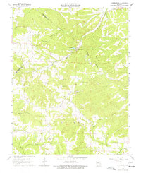
1964 Map of Lawrenceton
USGS Topo · Published 1977About this map
The small unincorporated community of Lawrenceton serves as the focal point of this 1964 survey of the northeastern Ozark Plateau. Situated along the banks of Fourche Du Clos, the settlement and its surrounding landscape are defined by a complex network of narrow hollows and winding ridges, including the prominent Pinhook Ridge. The map documents a scattered rural population through numerous family-named burial grounds, such as Beckemeyer Cem, Patterson Cem, and Mackley Cem, reflecting the deep-rooted genealogical history of the area.
Find a feature on this map
27 named features on this map. Tap any name to fly to it.
Don’t see what you’re looking for? This feature index may not catch every label — zoom into the map to look around manually.
Map Details
Editions of this 1964 Lawrenceton Map
3 editions found
Other maps of this area

1904 · Farmington
USGS Topo · 1:62,500

1906 · Farmington
USGS Topo · 1:62,500

1907 · Weingarten
USGS Topo · 1:62,500

1909 · Weingarten
USGS Topo · 1:62,500

1915 · Renault
USGS Topo · 1:62,500

1915 · Crystal City
USGS Topo · 1:62,500

1940 · Renault
USGS Topo · 1:62,500

1949 · Saint Louis
USGS Topo · 1:250,000

1949 · Rolla
USGS Topo · 1:250,000

1949 · Crystal City
USGS Topo · 1:62,500