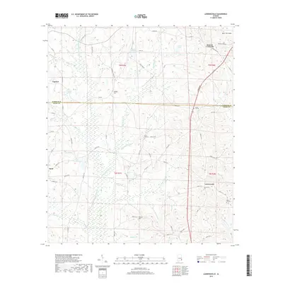
2018 Map of Lawrenceville
USGS Topo · Published 2018About this map
Lawrenceville and Richards Crossroads anchor this rural landscape in eastern Alabama, where the transition between the Baker Hill Cuesta and the lower coastal plain is marked by a dense network of creek drainages. The E Fork Choctawhatchee River and its numerous tributaries, including Beaver Cr and Piney Woods Cr, shape the local geography, creating the marshy wetlands surrounding Lake Choctawhatchee. Small agrarian settlements like Edwin, Holley Hill, and Edgefield are connected by a network of historic county roads, while several family and community burial grounds, such as Lawrenceville Cem and Mount Zion Cem, provide significant markers for genealogists. The topography is further defined by prominent rises like Vickers Hill, overlooking the Bowen Schoolhouse Br drainage. This survey reflects the enduring rural character of the Henry and Barbour County line, showing the persistence of traditional land divisions and remote homesteads in the Wiregrass region.
Find a feature on this map
80 named features on this map. Tap any name to fly to it.
Don’t see what you’re looking for? This feature index may not catch every label — zoom into the map to look around manually.
Map Details
Editions of this 2018 Lawrenceville Map
This is the sole edition of this map. No revisions or reprints were ever made.
Other maps of this area

1953 · Dothan
USGS Topo · 1:250,000

1954 · Dothan
USGS Topo · 1:250,000

1955 · Dothan
USGS Topo · 1:250,000

1967 · Clayton South
USGS Topo · 1:24,000

1968 · Baker Hill
USGS Topo · 1:24,000

1968 · Eufaula South
USGS Topo · 1:24,000

1969 · Abbeville West
USGS Topo · 1:24,000

1969 · Fort Gaines NW
USGS Topo · 1:24,000
1969 · Texasville
USGS Topo · 1:24,000
1969 · Clopton
USGS Topo · 1:24,000