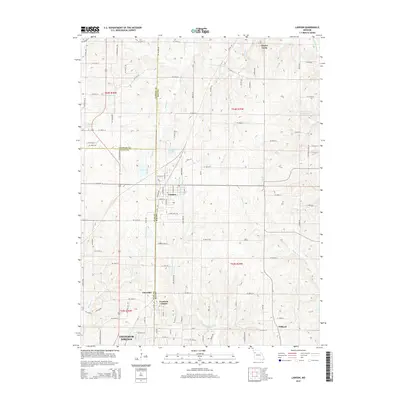
2014 Map of Lawson
USGS Topo · Published 2014About this map
The city of Lawson serves as a central hub where the boundaries of Ray, Clay, and Clinton counties converge. This 2014 survey captures the transition from small-town street grids to the undulating farmland and drainage basins of the Missouri interior. Waterways like the E Fork Fishing River and Burnt Fork carve through the landscape, defining the rural character between larger settlements. To the south, the northern edge of Excelsior Springs appears alongside the smaller community of Excelsior Estates. Farther east, the crossroads settlement of Vibbard and the quiet presence of Elmira Camp illustrate the dispersed nature of local residence and recreation in this part of Ray County. The map provides a detailed look at the modern road network, from SE Highway V to numerous section-line roads, revealing how the landscape has been partitioned and developed over generations of agricultural and residential use.
Find a feature on this map
106 named features on this map. Tap any name to fly to it.
Don’t see what you’re looking for? This feature index may not catch every label — zoom into the map to look around manually.
Map Details
Editions of this 2014 Lawson Map
This is the sole edition of this map. No revisions or reprints were ever made.
Other maps of this area

1894 · Independence
USGS Topo · 1:125,000

1924 · Polo
USGS Topo · 1:62,500

1925 · Plattsburg
USGS Topo · 1:62,500

1936 · Kearney
USGS Topo · 1:48,000

1942 · Kearney
USGS Topo · 1:62,500

1945 · Kearney
USGS Topo · 1:62,500

1950 · Kansas City
USGS Topo · 1:250,000

1954 · Kansas City
USGS Topo · 1:250,000

1956 · Kansas City
USGS Topo · 1:250,000
1957 · Knoxville
USGS Topo · 1:24,000