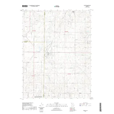
2017 Map of Lawson
USGS Topo · Published 2017About this map
Lawson sits at the intersection of Clay, Ray, and Clinton counties, serving as a central hub for this portion of northwest Missouri. The landscape is defined by the headwaters and intricate drainages of the E Fork Fishing River and the Crooked River, which carve a rolling topography through the agricultural plateaus. To the south, the map reaches the northern edge of Excelsior Springs, while the smaller settlement of Vibbard anchors the southeastern corner. Recreational and community landmarks like Lawson Lake and Wilderness Camp Lake appear alongside rural markers such as Washington School Rd, illustrating the blend of small-town development and traditional farm country. The numerous named watercourses, including Burnt Fork and Rocky Fork, reveal the natural drainage patterns that have historically dictated road placement and property boundaries in this three-county border region.
Find a feature on this map
113 named features on this map. Tap any name to fly to it.
Don’t see what you’re looking for? This feature index may not catch every label — zoom into the map to look around manually.
Map Details
Editions of this 2017 Lawson Map
This is the sole edition of this map. No revisions or reprints were ever made.
Other maps of this area

1894 · Independence
USGS Topo · 1:125,000

1924 · Polo
USGS Topo · 1:62,500

1925 · Plattsburg
USGS Topo · 1:62,500

1936 · Kearney
USGS Topo · 1:48,000

1942 · Kearney
USGS Topo · 1:62,500

1945 · Kearney
USGS Topo · 1:62,500

1950 · Kansas City
USGS Topo · 1:250,000

1954 · Kansas City
USGS Topo · 1:250,000

1956 · Kansas City
USGS Topo · 1:250,000
1957 · Knoxville
USGS Topo · 1:24,000