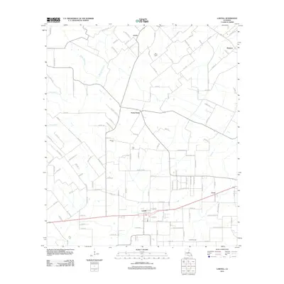
2012 Map of Lawtell
USGS Topo · Published 2012About this map
Lawtell serves as the primary hub of this St. Landry Parish landscape, characterized by its network of rural lanes and the prominent Lawtell Gas Field to the south. The terrain is defined by the winding paths of Bayou Grand Louis, Bayou Marron, and Bayou Doza, which carve through a mosaic of agricultural parcels. Significant genealogical landmarks are scattered throughout the region, including the Saint Andrews Cem, Bertrand Cem, and Pitre Cem, marking the long-standing family foundations of these communities. Smaller settlements like Prairie Ronde, Ledoux, and Veazie illustrate the dispersed pattern of rural life in the early 21st century. The map also documents essential infrastructure such as the local Po in Lawtell, providing a precise record of the parish's development and its enduring reliance on the land's natural watercourses and resources.
Find a feature on this map
123 named features on this map. Tap any name to fly to it.
Don’t see what you’re looking for? This feature index may not catch every label — zoom into the map to look around manually.
Map Details
Editions of this 2012 Lawtell Map
This is the sole edition of this map. No revisions or reprints were ever made.
Other maps of this area

1939 · Opelousas
USGS Topo · 1:62,500

1947 · Ville Platte
USGS Topo · 1:31,680

1947 · Chataignier
USGS Topo · 1:31,680

1947 · Pitreville
USGS Topo · 1:31,680

1952 · Lake Charles
USGS Topo · 1:250,000

1954 · Lake Charles
USGS Topo · 1:250,000

1956 · Opelousas
USGS Topo · 1:62,500

1957 · Opelousas
USGS Topo · 1:62,500

1957 · Carencro
USGS Topo · 1:62,500
1959 · Eunice
USGS Topo · 1:62,500