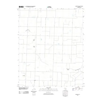
2010 Map of Lazbuddie
USGS Topo · Published 2010About this map
Lazbuddie anchors this High Plains landscape, situated at the intersection of FM 1172 and FM 145 in Parmer County. The region is defined by a strictly surveyed grid of county roads, such as Co RD 25 and Co RD 26, which facilitate the agricultural life of the Texas Panhandle. Water management is a primary feature of the local topography, evidenced by the Running Water Draw meandering across the southern portion of the sheet. Several water control structures, including Flynt Lake Number 1 Dam, Flynt Lake Number 2 Dam, and the Soil Conservation Service Site 3 Dam, demonstrate the critical role of soil conservation and irrigation in this semi-arid environment. For those researching local heritage, the Lazbuddie Cemetery serves as a vital touchstone for the community, located just south of the main settlement area.
Find a feature on this map
30 named features on this map. Tap any name to fly to it.
Don’t see what you’re looking for? This feature index may not catch every label — zoom into the map to look around manually.
Map Details
Editions of this 2010 Lazbuddie Map
This is the sole edition of this map. No revisions or reprints were ever made.
Other maps of this area

1954 · Clovis
USGS Topo · 1:250,000

1958 · Clovis
USGS Topo · 1:250,000

1963 · Flagg
USGS Topo · 1:24,000

1963 · Clays Corner
USGS Topo · 1:24,000

1963 · Lazbuddie
USGS Topo · 1:24,000

1963 · Dodd
USGS Topo · 1:24,000

1963 · Lazbuddie SW
USGS Topo · 1:24,000
1963 · Lazbuddie SE
USGS Topo · 1:24,000

1965 · Dimmitt SW
USGS Topo · 1:24,000

1965 · Tam Anne
USGS Topo · 1:24,000