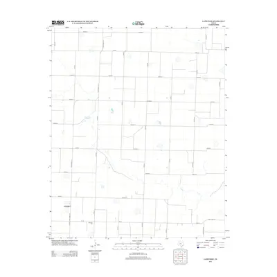
2012 Map of Lazbuddie
USGS Topo · Published 2012About this map
Lazbuddie anchors this agricultural section of the Texas Panhandle, positioned at the intersection of Ranch Road 1172 and FM-145. The surrounding landscape is defined by the rigid geometry of the High Plains grid, where numerous county roads like Co Road R and Co Road Y partition the terrain into large-scale cultivation plots. The map reveals the critical importance of local water management in this arid region, highlighted by ephemeral features such as Flynt Lake Number 1 and various unnamed playa lakes that dot the plains.
Find a feature on this map
31 named features on this map. Tap any name to fly to it.
Don’t see what you’re looking for? This feature index may not catch every label — zoom into the map to look around manually.
Map Details
Editions of this 2012 Lazbuddie Map
This is the sole edition of this map. No revisions or reprints were ever made.
Other maps of this area

1954 · Clovis
USGS Topo · 1:250,000

1958 · Clovis
USGS Topo · 1:250,000

1963 · Flagg
USGS Topo · 1:24,000

1963 · Clays Corner
USGS Topo · 1:24,000

1963 · Lazbuddie
USGS Topo · 1:24,000

1963 · Dodd
USGS Topo · 1:24,000

1963 · Lazbuddie SW
USGS Topo · 1:24,000
1963 · Lazbuddie SE
USGS Topo · 1:24,000

1965 · Dimmitt SW
USGS Topo · 1:24,000

1965 · Tam Anne
USGS Topo · 1:24,000