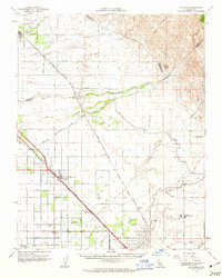
1961 Map of Le Grand
USGS Topo · Published 1963About this map
The agricultural landscape of the San Joaquin Valley is defined here by the converging paths of the Atchison Topeka and Santa Fe Railroad and the Southern Pacific Railroad through Merced and Madera Counties. Large-scale ranching and irrigation infrastructure shape the terrain, with features such as the Raynor Ranch and Ash Slough illustrating the region's managed water systems. The map captures the presence of the Madera Air Force Station on the plains, while rural life is anchored by local institutions like Dixieland Sch and the community of Le Grand. To the east, the flat valley floor begins to give way to rising ground at Table Mtn. A network of numbered avenues and named roads, including Buchanan Hollow Road, connects smaller settlements like Sharon, Berenda, and Kismet, which served as vital transit points for the local rail and orchard economy.
Find a feature on this map
55 named features on this map. Tap any name to fly to it.
Don’t see what you’re looking for? This feature index may not catch every label — zoom into the map to look around manually.
Map Details
Editions of this 1961 Le Grand Map
This is the sole edition of this map. No revisions or reprints were ever made.
Other maps of this area

1912 · Mariposa
USGS Topo · 1:125,000

1915 · Owens Creek
USGS Topo · 1:31,680

1916 · Berenda
USGS Topo · 1:31,680

1918 · Owens Creek
USGS Topo · 1:31,680

1918 · Chowchilla
USGS Topo · 1:31,680

1918 · Berenda
USGS Topo · 1:31,680
1918 · Planada
USGS Topo · 1:31,680

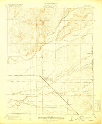
1918 · La Grand
USGS Topo · 1:31,680

1919 · Indian Gulch
USGS Topo · 1:48,000

1919 · Plainsberg
USGS Topo · 1:31,680