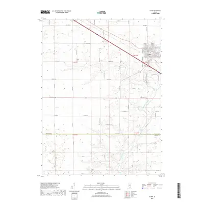
2018 Map of Le Roy
USGS Topo · Published 2018About this map
Le Roy serves as the primary urban center for this section of McLean County, characterized by a tight residential grid bounded by the modern interstate and local routes like Co Hwy 21. The surrounding landscape is defined by the agricultural sections of Central Illinois, where the drainage of the W Fork Salt Cr and the North Fork Salt Creek meanders through the township lines of t22n r4e and t21n r4e. These waterways have historically dictated the placement of small, localized landmarks that remain essential for genealogical research. Scattered among the farm roads are several early burial grounds, including Rutledge Cem to the west, Gilmore Cem near the town's edge, and Walden Cem further south toward the De Witt County line. The presence of Clyde Vance Lake adds a distinct water feature to the otherwise structured rural topography.
Find a feature on this map
95 named features on this map. Tap any name to fly to it.
Don’t see what you’re looking for? This feature index may not catch every label — zoom into the map to look around manually.
Map Details
Editions of this 2018 Le Roy Map
This is the sole edition of this map. No revisions or reprints were ever made.
Other maps of this area

1937 · Monticello
USGS Topo · 1:48,000

1943 · Monticello
USGS Topo · 1:62,500

1951 · Le Roy
USGS Topo · 1:62,500

1952 · Arrowsmith
USGS Topo · 1:62,500

1957 · Maroa
USGS Topo · 1:62,500

1958 · Peoria
USGS Topo · 1:250,000

1961 · Peoria
USGS Topo · 1:250,000

1963 · Peoria
USGS Topo · 1:250,000

1979 · De Witt
USGS Topo · 1:24,000
1979 · Farmer City South
USGS Topo · 1:24,000