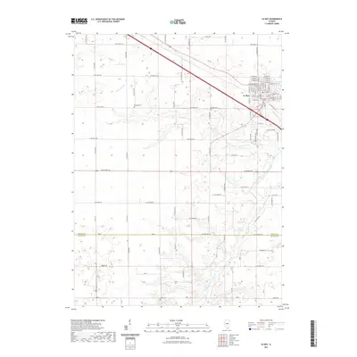
2021 Map of Le Roy
USGS Topo · Published 2021About this map
Le Roy serves as the primary hub of this Central Illinois landscape, where the town’s established grid gives way to the agricultural expanses of southern McLean County and northern DeWitt County. The map details the transition from the structured streets of the city, such as W Washington St and E School St, to the rural sections divided by a network of range and township roads. Waterways like W Fork Salt Cr and the North Fork Salt Creek carve through the prairie, defining the drainage patterns that have historically shaped the local farming economy. Genealogists and local historians will find significant value in the preservation of several rural burial grounds, including Rutledge Cem, Gilmore Cem, and Walden Cem, which are clearly marked along the section lines and creek bends. Near the southern border, Clyde Vance Lake and the McLean Co De Witt Co boundary line provide distinct markers of the regional geography.
Find a feature on this map
85 named features on this map. Tap any name to fly to it.
Don’t see what you’re looking for? This feature index may not catch every label — zoom into the map to look around manually.
Map Details
Editions of this 2021 Le Roy Map
This is the sole edition of this map. No revisions or reprints were ever made.
Other maps of this area

1937 · Monticello
USGS Topo · 1:48,000

1943 · Monticello
USGS Topo · 1:62,500

1951 · Le Roy
USGS Topo · 1:62,500

1952 · Arrowsmith
USGS Topo · 1:62,500

1957 · Maroa
USGS Topo · 1:62,500

1958 · Peoria
USGS Topo · 1:250,000

1961 · Peoria
USGS Topo · 1:250,000

1963 · Peoria
USGS Topo · 1:250,000

1979 · De Witt
USGS Topo · 1:24,000
1979 · Farmer City South
USGS Topo · 1:24,000