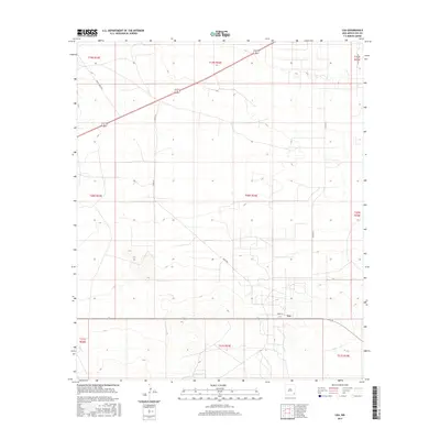
2017 Map of Lea
USGS Topo · Published 2017About this map
The settlement of Lea sits at a remote junction in the southeastern New Mexico desert, surrounded by the geometric precision of the Public Land Survey System. The landscape is defined by vast township and range divisions, such as t20s r34e and t21s r33e, which organize this arid ranching and energy-producing region. Local transportation relies on a sparse network of dirt and gravel paths, including Skeen Rd and Smith Ranch Rd, which stretch across the high plains to connect isolated homesteads and industrial sites. In a region where water is a critical resource, the presence of South Tank indicates the essential infrastructure required for livestock management and survival in the Llano Estacado. The map reveals how modern naming conventions like Orion Ln and Willow Tree Rd intersect with traditional ranching corridors, reflecting the evolving human footprint on this open terrain.
Find a feature on this map
16 named features on this map. Tap any name to fly to it.
Don’t see what you’re looking for? This feature index may not catch every label — zoom into the map to look around manually.
Map Details
Editions of this 2017 Lea Map
This is the sole edition of this map. No revisions or reprints were ever made.
Other maps of this area

1954 · Hobbs
USGS Topo · 1:250,000

1958 · Hobbs
USGS Topo · 1:250,000

1963 · Oil Center
USGS Topo · 1:62,500

1963 · Monument
USGS Topo · 1:62,500

1963 · Laguna Gatuna
USGS Topo · 1:62,500

1963 · Hat Mesa
USGS Topo · 1:62,500

1978 · Jal
USGS Topo · 1:100,000

1984 · Lea
USGS Topo · 1:24,000

1984 · Ironhouse Well
USGS Topo · 1:24,000
1984 · Grama Ridge
USGS Topo · 1:24,000