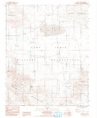
1985 Map of Leach Lake
USGS Topo · Published 1985About this map
Fort Irwin Military Reservation dominates this high-desert landscape in the mid-1980s, serving as a backdrop for specialized training and testing activities. Centrally located, Leach Lake appears as a prominent dry lake bed, complete with a designated Airfield and numerous Target markers scattered across its surface. The presence of an Ammunition Disposal Pit and several Located Object labels underscores the area's intensive military utility during this era.
Find a feature on this map
17 named features on this map. Tap any name to fly to it.
Don’t see what you’re looking for? This feature index may not catch every label — zoom into the map to look around manually.
Map Details
Editions of this 1985 Leach Lake Map
2 editions found
Other maps of this area

1933 · Avawatz Mountains
USGS Topo · 1:250,000

1947 · Trona
USGS Topo · 1:250,000

1948 · Trona
USGS Topo · 1:250,000

1948 · Quail Mountains
USGS Topo · 1:62,500

1948 · Leach Lake
USGS Topo · 1:62,500

1948 · Goldstone Lake
USGS Topo · 1:62,500

1948 · Tiefort Mountains
USGS Topo · 1:62,500

1951 · Goldstone Lake
USGS Topo · 1:62,500

1951 · Tiefort Mountains
USGS Topo · 1:62,500

1951 · Quail Mountains
USGS Topo · 1:62,500